The Buildings of Sharrington in 1784
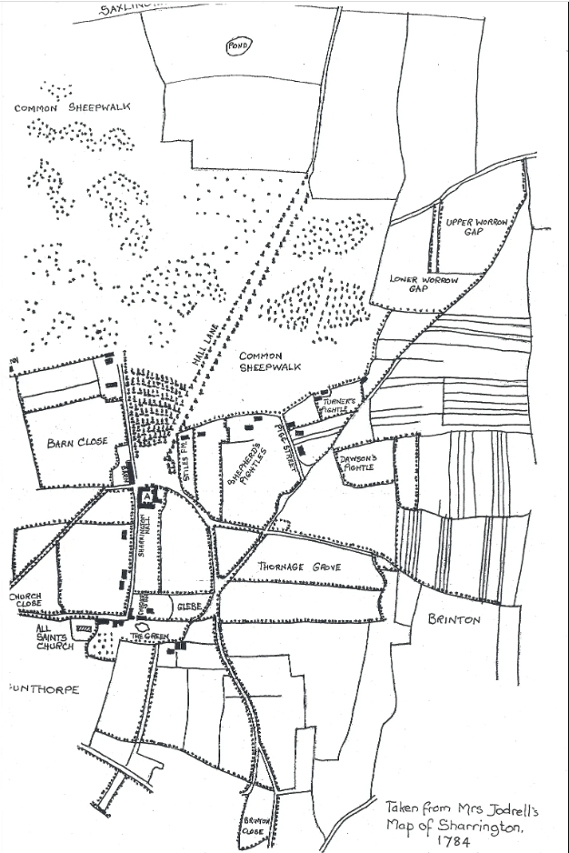
The first map of Sharrington, of any accuracy, that we have, is the Estate Map prepared by Mr. C. Bell for Elizabeth Jodrell, widow, of 1784, being the estate owner at that time. Although mainly interested in her own holdings, the map does show most of the buildings and plots of land as they were situated at that time and, therefore, already in existence before 1784.
Daubeney Hall Farm
During the tenure of the Daubeney Lords, the old manor house (Sharrington hall) is believed to have been called Daubeney Hall and, during that period, probably in the 15th or 16th Century, Daubeney Hall Farm would have been built, which was probably the residence of the Estate Farm Manager. However, in 1784, the farmhouse and the land behind was in the residence of the Reverend Mr. Cory, so the farm may have passed out of the estate’s ownership at this time.
[Now a Grade II listed building with Historic England. ]
Hunt Hall and Hunt Hall Farm
Sharrington Hall had passed from the Daubeneys to the Hunt Family by 1601 with William Hunt Lord of the manor.
In 1645, on an inquisition of lunacy, it was found that Margaret, ……”widow of William Hunt, son and heir of Sir Thomas Hunt, was a lunatic, and seized for life of the manors of Sharrington, Holt Hales, Geyst and Wichingham, &c. and Thomas Hunt, Gent. was her son and heir, and married to Anne, daughter of John Sherwood, M.D.” [1]
It was possible that sometime in the 17th century, Hunt Hall Farm was built. However, by 1768, the Freeholder of Hunt Hall Farm was William Bangay. In 1806, a William Bangay was the occupier but not the owner of the property, which was owned by Francis Mann of Thornage, a member of the Bangay family. Hunt Hall Farm was in the occupation of the Bangay family until 1868.
After the Hunt family, Sharrington Hall was conveyed to Mr. Newman Gent., whose son and heir, William Newman Esq. was Lord and High Sheriff of Norfolk in 1702, and Patron of All Saints Church. By 1720, the estate had passed to Richard Warner Esq. of Elmham and by 1758 to the Jodrell family.
Other Buildings present in 1784
There are other old buildings still standing which are shown on Mrs. Jodrell’s map.
- The Barn, opposite Sharrington Hall, marked Barn Yard, and now converted into private dwellings.
- The White Swan Inn, Holt Road licensed as a public house “an ancient and well known inn advertised for sale on Saturday 13th June 1778”. Owned originally by the Jodrell family and then sold to the White family who finally sold it for conversion to a private dwelling in 1953.
There may be other buildings still standing since 1784, but it is difficult to tell from the map, as it is mainly concerned with Mrs. Jodrell’s property. Also, more modern buildings may have been built on the same sites.
An anomaly on the map shows ‘The Chequers’ public house which suggests another hand has altered this map. ‘The Chequers’ was known as ‘Hastings Arms’ until 1890, as it was owned by Lord Hastings.
Buildings Demolished Since 1784.
As previously stated, there were no buildings on the north side of, what is now, “The Street” in 1784, except for buildings on the Holt Road towards the direction of The Swan Public House.
There were no buildings north of “The Street” as this was Sharrington Common or The Common Sheepwalk.
On Mrs. Jodrell’s map, there are three buildings shown on the south side, to the east of Stiles Farm, alongside land marked “Shepherds Pightles”. Two of these buildings were, most probably, shepherd’s dwellings and marked as being owned by the Estate. These three buildings have long been demolished.
In the field to the east of New Road and The Street, two houses are shown alongside land marked as “Turner’s Pightle”. These premises are also long demolished but, after ploughing, the locations of these properties, marked by flints and bricks are clearly visible.
Also, along the east side of The Street, buildings are shown, one probably on the site of the present Village Hall, which has a capped well in front of it. These buildings, and no doubt others, have been demolished.
Stiles Farm
This farmhouse is considered in some detail, as it forms an interesting and significant section of the history of Sharrington. Stiles Farm is situated on the corner of The Street and Hall Lane. It is, like all the old buildings in Sharrington, of flint construction and it has a well sunk in the front garden.
The first record of Stiles Farm and the land behind is from 26th. July 1654, when, according to The Court of Sharrington Manor, it is a “Copyhold Estate”, the definition of which is “a species of estate or right of holding land according to the custom of the manor, by copy of the roll originally made by the Steward of the Lord’s Court”. The holder of the Messuage (a dwelling with the adjoining lands appropriated to the household) at that date was John JUDE and Jane, his wife. Therefore, Stiles Farmhouse was built before 1654.
On 26th July 1654, JON Jude surrendered “the messuage and one acre with Brinton Close of Five Roads” to Robert Burton Gent. “Brinton Close of Five Roads”, from Mrs. Jodrell’s map, would appear to be what is locally known as Lower Sharrington, but is now, generally thought of as part of Brinton. If you walk down the hill from Sharrington towards Brinton, at the place where the little lane forks off to the right, that is the commencement of Brinton Close, being enclosed by five lanes (roads) at that time, with the stream running through it and part of Sharrington Parish.
On the 15th October 1680, during the reign of Charles II, the property was surrendered to Thomas Moore, who died and was buried in Sharrington Churchyard on 9th August 1699. Thomas left the property to his wife Hester and his daughter Anne, wife of Edmund Girdlestone.
In 1743, Thomas Girdlestone, son and heir of Anne, obtained the property, but then there is an extraordinary record. “It was the time at which the cottage and grounds were obtained freehold by a fraud against the Manor Estate”. However, there is no explanation of this. In 1745, the property seems to have been divided within the family, part of which inherited and occupied 5 Road Croft, Brinton Close.
On 4th October 1751, Robert Spencer, Yeoman, and Anne, his wife, daughter of Thos. Girdlestone, were the owners of Stiles Farm, which was in the occupation of the Widow Williamson ? In 1765, Robert Spencer left the property to his son, also named Robert. This Robert, who was a miller of Briston, sold the property to Robert Sharpin, farmer of Thurning, and Jos. Woodcock, Grocer and Draper of Brinton, but the cottage was said to be in the occupation of Joseph Dennis.
On 10th January 1801, the property was sold to the Jodrell Estate for £250 by Robert Sharpin. So Stiles Farm returned to the ownership of the Sharrington Manor, then part of the Jodrell Estate. In 1890 the Jodrell estate of Sharrington was sold to Major Timothy White of Salle Park and here it remained, with various tenants, until sold to private ownership in the 20th century.
Medieval Stone Cross
There are the remains of a stone column, which was restored by the Jodrell estate, at the junction of Bale Road and the lane which leads to Sharrington Hall. It is said that it could be the remains of a Pilgrim’s Cross on a route to the Walsingham shrine from the Norfolk coastal ports of Blakeney and Cley to the north. In Catholic Countries, as this was at the time it was built, crosses are erected everywhere and many survive in this country in towns and villages.
….”The monument includes a standing stone cross situated c.80m ENE of All Saints Church, Sharrington, on a small island at the junction of two roads. The cross, which is Listed Grade II, includes a brick foundation, a socket stone and the lower section of the shaft, which are both of medieval date, two upper sections of the shaft which are part of a modern restoration, a capital which is also modern, and the broken base of the head”……… [Reference: Historic England entry].
‘New Building’ in Sharrington
In 1784, there were fewer roads or lanes in Sharrington but, according to a Tithe Map, by 1841, the road system had, more or less, been increased to the present layout. Most notably, The Street, then known as Pigg Street, had been lengthened and connected to Hall Lane near Stiles Farm.
The Jodrell Estate had constructed semi-detached farm labourers’ cottages, some of which are still standing and in the occupation of private owners. In Pigg Street, No’s 1 and 2 have been combined into one dwelling and ‘The Cottage’ is also a former semi detached estate cottages converted into one dwelling. Number’s 14/15,16/17,18 /19 are still relatively unchanged estate workers semi-detached properties, now in private ownership. There is also a pair of semi detached cottages in Bale Road numbers 22/23. The remainder of the series of Farm Workers’ cottages have been demolished.
It is not known why the White Family, when they acquired the estate, altered the dates on the front of the cottages to the 1870’s. Also, early in the 19th Century, several dwellings were built on the north side of Pigg Street, near to New Road, on what had been part of The Common Sheepwalk. Although some of these buildings have been demolished, three dwellings, Well Cottage to Flint Cottage are still standing and in private ownership.
[1] An Essay Towards A Topographical History of the County of Norfolk: Volume 9. London, 1808.